


 NEWS
Aeronext and SkymatiX Announce Business Partnership to Jointly Develop and Deploy Solutions Combining Japan-Made Drones with GEOINT Data Platform
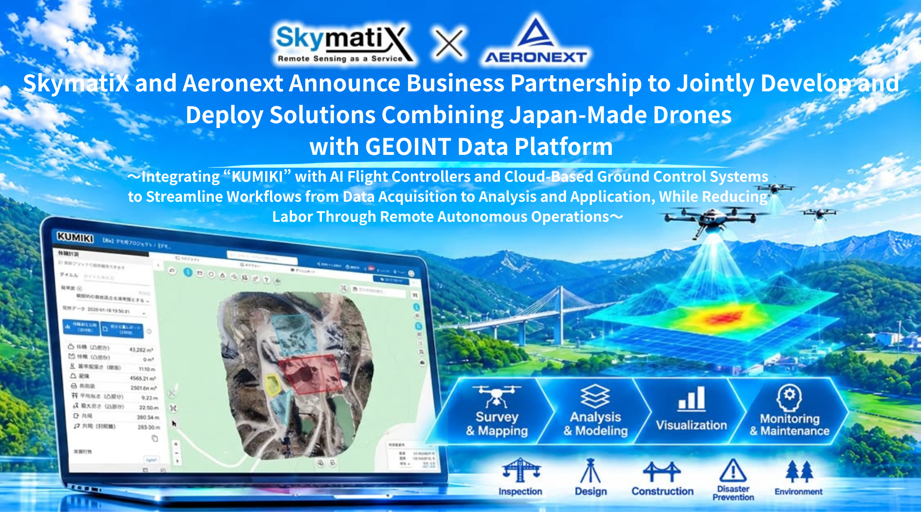
~Integrating “KUMIKI” with AI Flight Controllers and Cloud-Based Ground Control Systems to Streamline Workflows from Data Acquisition to Analysis and Application, While Reducing Labor Through Remote Autonomous Operations~
Aeronext Inc. (Head Office: Shibuya-ku, Tokyo; President & CEO: Keisuke Toji; hereinafter “Aeronext”) and SkymatiX Inc. (Head Office: Chuo-ku, Tokyo; President: Zentaro Watanabe; hereinafter “SkymatiX”) are pleased to announce that they have entered into a business partnership agreement to jointly develop, commercialize, and deploy solutions that combine Japan-made drones with an integrated geospatial data platform.
Through this partnership, the two companies aim to develop a Japan-made GEOINT (Geospatial Intelligence)*1 solution that integrates the entire process, from data acquisition to the analysis and utilization of geospatial data. The solution will combine SkymatiX’s GEOINT platform, “KUMIKI,” with drones, AI flight controllers*2, cloud-based Ground Control Systems (GCS), and remote autonomous operation technologies developed and owned by Aeronext and its group companies.
Looking ahead, the companies will leverage remote autonomous operations and the simultaneous operation of multiple drones to automate and reduce the labor required for data acquisition across a wide range of industries, including construction, surveying, infrastructure inspection, disaster preparedness, and agriculture and forestry. They also aim to advance GEOINT solutions that use continuously acquired geospatial data to identify changes and anomalies in the real world and translate these insights into business decisions and actions.
Background and Objectives of the Business Partnership
In recent years, demand for drone-based data acquisition and analysis has been growing in fields such as construction, surveying, infrastructure inspection, disaster preparedness, and agriculture and forestry, driven by increasingly severe labor shortages and the need to address aging infrastructure.
To expand the industrial use of drones more widely, however, it is essential to go beyond improving aircraft performance and establish integrated solutions that encompass flight automation, more efficient flight operations management, and the analysis and utilization of acquired data. It is also important to move beyond one-off imaging and surveying and make effective use of data for continuous situational monitoring and on-site decision-making.
Furthermore, from the perspectives of information security, supply chain resilience, and economic security, reducing dependence on foreign-made drones and related systems has become increasingly important. This has created a growing need to develop solutions centered on domestic technologies and businesses and establish stable operational frameworks.
SkymatiX provides “KUMIKI,” a GEOINT platform that brings together data from drones, satellites, and other sources for processing, analysis, and visualization, helping users gain a clearer understanding of on-the-ground conditions and make informed decisions. SkymatiX is also working to drive the practical adoption of GEOINT across industries.
Aeronext, meanwhile, is advancing the deployment of drone technologies and the more advanced drone operations through its proprietary drone airframe design technology, as well as AI flight controllers, cloud-based GCS, and remote autonomous operation technologies.
By combining their respective technologies, customer bases, and business development capabilities, the two companies will enhance the workflow from drone-based data acquisition through analysis and utilization, and promote the joint development and real-world deployment of Japan-made drone solutions designed for industrial applications.
Overview of the Business Partnership
1. Agreement Date November 10th, 2026
2. Objectives and Scope of Collaboration
① Joint Planning, Development, and Commercialization of Japan-Made Drones Integrated with “KUMIKI”
By combining SkymatiX’s understanding of customer needs and expertise in geospatial data utilization with Aeronext’s drone development and system integration technologies, the two companies aim to jointly plan, develop, and commercialize Japan-made drones suited to industrial applications such as construction, surveying, and infrastructure inspection.
② Integration of AI Flight Controllers and Cloud-Based GCS with “KUMIKI”
The companies will work to integrate AI flight controllers and cloud-based GCS developed by the Aeronext Group with SkymatiX’s “KUMIKI” platform. This integration is intended to seamlessly connect the entire workflow—from flight planning and data acquisition to data transmission, processing, analysis, visualization, and utilization—while improving efficiency and automation at each stage.
③ Advanced Data Acquisition Through Remote Autonomous Operations and the Simultaneous Operation of Multiple Drones
By leveraging remote autonomous operation and technologies for operating multiple drones simultaneously, the companies aim to establish an operational model that reduces the burden on on-site drone operators while enabling wide-area and high-frequency data acquisition. The companies aim to move beyond one-off drone imaging and surveying toward GEOINT services that continuous monitoring and analysis of real-world conditions and changes, turning geospatial data into actionable insights.
④ Joint Demonstrations and Real-World Deployment Across a Broad Range of Industries
The companies will pursue joint demonstrations, market validation, and customer development in a wide range of fields, including construction, surveying, infrastructure inspection, disaster preparedness, agriculture and forestry, and local government services.
Through collaboration with national and local governments and private-sector companies, they will also promote the development and deployment of solutions that address real-world operational challenges.
⑤ Establishment of a Supply Chain for Japan-Made Drones and Development of Business Models
The companies will jointly explore the establishment of a supply chain for Japan-made drones, taking into consideration information security, supply stability, and economic security. In addition to aircraft sales, they aim to develop sustainable service offerings and business models that combine software licensing fees, cloud service fees, and maintenance and operational service fees.
3. Roles of Each Company
Aeronext Inc.
Provision of technologies for the planning and development of Japan-made drones
Provision of AI flight controllers and cloud-based GCS
Provision of remote autonomous operation and multi-drone simultaneous operation technologies
Support for the development of drone operation expertise and safe operational frameworks
Support for airframe development, system integration, and real-world deployment
SkymatiX Inc.
Provision of the geospatial data integration platform “KUMIKI”
Provision of technologies for the integration, processing, analysis, and utilization of geospatial data
Identification of customer needs and organization of product requirements
Product planning and solution design
Market development leveraging its customer base and sales network
4. Future Outlook
The two companies will explore technical integration between “KUMIKI” with Japan-made drones, while pursuing joint demonstrations and market validation for specific industrial applications.
In particular, by combining remote autonomous drone operations and the simultaneous operation of multiple drones with geospatial data analysis, they aim to reduce the labor required for data acquisition and develop services built around continuous data collection and analysis.
Looking ahead, the companies will advance the real-world deployment of GEOINT, moving beyond the use of drones solely as photography and surveying equipment. Their goal is to automatically and continuously acquire the necessary data, analyze real-world conditions and changes, and translate the resulting insights into business decisions and actions.
Through the integration of Japan-made drone technologies and GEOINT technologies, the two companies will create new solutions that connect the entire process from data acquisition to decision-making, contributing to stronger industrial competitiveness in Japan and the development of sustainable social infrastructure.
Reference
*1 GEOINT
GEOINT (Geospatial Intelligence) refers to the collection, integration, and analysis of geospatial data to generate actionable insights about locations, conditions, and changes in physical world, supporting informed decision-making.
*2 AI Flight Controller
A next-generation flight control system that incorporates artificial intelligence technologies, including deep learning, to optimize the attitude and flight speed of drones and other aircraft in real time based on sensor data.
【About SkymatiX Inc.】
Guided by its mission, “Realizing a New Society Through Remote Sensing,” SkymatiX is a technology company dedicated to making GEOINT (Geospatial Intelligence) accessible and actionable. By integrating and analyzing geospatial data from satellites, drones, smartphones, ground-based sensors, and other sources, SkymatiX helps organizations better understand the physical world and make informed decisions.
Through its geospatial intelligence platform, KUMIKI, and related services, SkymatiX has supported the adoption of GEOINT across 30 industries and more than 50,000 sites to date, including construction, infrastructure management, disaster management, and agriculture and forestry.
By making the invisible visible, SkymatiX aims to address critical challenges such as labor shortages, aging infrastructure, and increasingly severe natural disasters, making GEOINT an essential tool for everyday decision-making.
“KUMIKI” Official Website: https://kumiki.com/
SkymatiX Official Website: https://skymatix.co.jp/
Head Office: 6F Daiwa Nihonbashi Honishicho Building, 4-2-16 Nihonbashi Honishicho, Chuo-ku, Tokyo
Representative: Zentaro Watanabe, President
Capital: JPY 100,000,000
Business: Planning, development, and sales of industrial remote sensing services
*Aeronext and the Aeronext logo, “4D GRAVITYTM” and “SkyHubTM” are trademarks of Aeronext Inc.
*Other company and product names mentioned in this press release are registered trademarks or trademarks of their respective companies.
Related article
-
Aeronext and SkymatiX Announce Business Partners...
Learn more
-
NEXT DELIVERY, Aeronext, and Daiwa House Industr...
Learn more
-
Aeronext Joins Exa’s Physical AI Platform Develo...
Learn more
-
Aeronext and Yamatane Enter into Business Partne...
Learn more
-
Shoei Yakuhin and Aeronext Enter into Capital an...
Learn more
-

CHANGE Holdings, Toko Computer Service, Aeronext...
Learn more